Sal, Cape Verde
| Native name: Dja d’ Sal’ Sobriquet: Ilha do aeroporto (island of the airport) |
|
|---|---|
 |
|
 |
|
| Geography | |
| Location | Atlantic Ocean |
| Area | 216 square kilometres (83 sq mi) |
| Length | 30 kilometres (19 mi) |
| Width | 12 kilometres (7.5 mi) |
| Highest elevation | 406 metres (1,332 ft) |
| Highest point | Monte Vermelho |
| Country | |
|
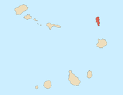
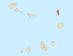
Cape Verde
|
|
| Concelhos (Municipalities) | Sal |
| Largest city | Espargos |
Sal (Portuguese for “salt” — from the mines at Pedra de Lume) is an island in Cape Verde. It belongs to the northern group of islands, called Barlavento. The island is composed by a single administrative division, the Sal municipality. The island is home to Amílcar Cabral International Airport, the main airport of Cape Verde.
Contents |
Geography
| Sal | ||
| Municipality | ||
|
||
| Island | Sal | |
|---|---|---|
| Seat town | Espargos | |
| Area | 216 km² (83 sq mi) | |
| Population | 17,631 (2005[1]) | |
| Density | 82 / km² (212 / sq mi) | |
| ISO 3166-2 code | CV-SL | |
| CGN-CV code | 41 | |
| Demonym | Salense m, ~s pl | |
 |
||
| Website: http://www.municipiodosal.cv | ||

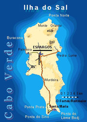
The island is 30 km long by 12 km wide. It is one of the three sandy eastern islands (Sal, Boa Vista and Maio) of the archipelago, with white sandy beaches and fairly flat. The highest elevation of 406 m is at Monte Grande. Serra Negra has a height of 92 m.
Climate
Sal Island has on average 350 days of sunshine a year. Winds mainly blow from the northeast. However, many days do also have cloud, but it tends to be broken and seldom brings rain. The 'rainy season' is from August to mid-October, although rainfall is still low.
History
The island was discovered on December 3, 1460 and named Llana until salt deposits were found. Sal is the geologically oldest island in Cape Verde, formed 50 million years ago during the eruption of a volcano which is now inactive.
The municipality was created in 1935, when, due to a population increase, it was separated from the older Municipality of Boa Vista.
Economy
Sal’s main town, Vila dos Espargos, is home to one of the nation’s international airports and has around 8,000 inhabitants. Its population grew around salt collection and later shifted to fishing, but is now based on tourism (amounting to 50% of the archipelago’s tourism) at the beach resort of Santa Maria.
Its airport, Amilcar Cabral International Airport, was used as a refuelling base by South African Airways on its Johannesburg to London routes. This was necessitated by the refusal of Black African states to the North to grant overflying permission and direct routing to and from Europe. Later, flights to and from New York and Atlanta also refuelled there, and the island was a crew-change station. SAA established the long runways needed by the fully-fueled Boeing 707s on their take-offs in the high temperatures. On July 1, 2006, SAA operated its final flight to Sal due to the ending of its flights to Atlanta.
Saline marshes can be found in the Pedra de Lume crater and north of Santa Maria.
Transportation
The major roads on the island are:
- Santa Maria - Espargos Road (paved)
- Palmeira - Espargos Road (narrowly paved)
- Pedra de Lume - Espargos Road (paved)
- Espargos - Reguinho Fiúra Road (unpaved)
Settlements
There are six inhabited centers:
-
- Pedra de Lume, on the eastern coast, is the most ancient, and the home of the first salt workers. Today it is only a small village with very few inhabitants.
- Palmeira is a fishing village, built around a port situated on the opposite coast of the island. It is also a small village but is growing. Palmeira is also home to the island of Sal's port.
- Espargos (pop: 6,173 (2005)[2]) for the town, 8,000 including Hortelão and Preguiça) is the main urban center and is situated between Pedra de Lume and Palmeira. It was formed around the international airport named after Amilcar Cabral (IATA airport code SID) located in the heart of the island.
- Terra Boa is the only place on the island where agriculture can be found on a large scale, as the island is very dry, mainly because it has no mountains to induce rainfall. This place is situated north of Espargos.
- Murdeira is a tourist resort, which is growing in population.
- Santa Maria (pop: 20,114 (2008)[3]), which was a former salt working village, is now the tourism center of the island.
Other inhabited settlements are:
-
- Feijoal, 1 km west of Pedra de Lume.
- Fontona, south of Palmeira.
- Reguinho Fiúra, a remote village near a lighthouse and overlooking Ponta Norte, the island's northernmost point.
Demography
| Population of Sal, Cape Verde (1940—2010) | |||||||
|---|---|---|---|---|---|---|---|
| 1940[4] | 1950[4] | 1960[4] | 1970[4] | 1980[4] | 1990[4] | 2000[5] | 2010[6] |
| 1121 | 1838 | 2608 | 5505 | 5826 | 7715 | 14816 | 20702 |
Persons
- Ildo Lobo – musician
- Josh Angulo - professional windsurfer
References
External links
|
||||||||||||||
|
|||||||||||||
|
||||||||